
What is GPXSee?
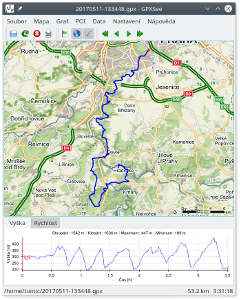
GPXSee is a GPS log file viewer and analyzer that supports all common GPS log file formats.
Key features
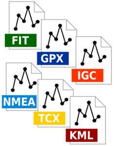
- Opens GPX, TCX, FIT, KML, NMEA, IGC, CUP, SIGMA SLF, Suunto SML, LOC, GeoJSON, OziExplorer (PLT, RTE, WPT), Garmin GPI & CSV and geotagged JPEG files.
- User-definable online maps (OpenStreetMap/Google tiles, WMTS, WMS, TMS, QuadTiles).
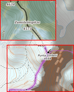
- Offline maps (OziExplorer maps, TrekBuddy maps/atlases, Garmin IMG/GMAP & JNX maps, TwoNav RMaps, GeoTIFF images, MBTiles).
- Elevation, speed, heart rate, cadence, power, temperature and gear ratio/shifts graphs.
- Support for DEM files (SRTM HGT).
- Support for POI files.
- Print/export to PDF.
- Multiple tracks in one view.
- Full-screen mode.
- HiDPI/Retina displays & maps support.
- Native GUI (Qt) for Windows, Mac OS X and Linux.
- Free software (GPLv3 open-source license).
GPXSee is designed as a small (no dependencies except of Qt), fast and uncomplicated GPS data/map viewer, not a full featured GIS software. However, the spectrum of supported data files/map sources is relatively rich, see the Documentation section for details.
Getting GPXSee
Additionally to the source codes, GPXSee is available as a Windows installer and an OS X dmg from the project's Sourceforge page and in form of various Linux packages from the project's openSUSE Build Service page. Most Linux distributions (Archlinux, Fedora, Gentoo, openSUSE, ...) as well as BSD distributions (FreeBSD, NetBSD, OpenBSD) also provide GPXSee in their official repositories, however not always in the latest version.
On OS X you can also use the MacPorts or Homebrew packaging systems to install GPXSee.
The official Windows & OS X installers are always signed using certificates available at the GitHub project page. As the certificates are non-commercial (self-signed) you have to import the certificate on Windows first if you want your OS automatically check the installer when installing GPXSee. On OS X, Apple does not allow software that does not generate them profit like GPXSee to pass Gatekeeper (you can't import custom certificates) so you need to run the application using the "right click menu" when opening it for the first time.
Maps
GPXSee supports most tile server based online maps out there, but the list of map definitions distributed with the official packages is limited to a small set of well known global map services. You may however easily extend (or change) the default map list with your own map definitions.
There is a community driven GPXSee maps repository on GitHub where you can find a lot of additional map definitions for various map services, usually run by some state geographic institution or a non-profit organization.
Reporting bugs
If you have found a bug in GPXSee, please report it using the GitHub issue tracker. Bugs that are not reported can not be fixed! If you are missing some feature in GPXSee, you may also use the tracker to request it.
Bad/missing translations can be fixed directly on the projects Weblate page.